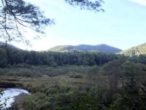
This 114,010 acre state wilderness area contains 33 bodies of water and more than 50 miles of trails.
There are several access points in the western part of Johnsburg along route 28 and route 8.
17 of the trails in the park are designated and marked and will have trail signs and markers. The remaining trails are unmarked. Make sure to have a map and compass.
See a map locating the trails in Warren County on our Hiking in Warren County page.
These trails are in or partly in the town of Johnsburg:
Balm of Gilead Mountain Trail
Bog Meadow Trail
Botheration Pond Trail
East Branch Gorge Path
Elizabeth Point Spur Trail
East Puffer Pond Trail
Hour Pond Trail
John Pond – Clear Pond Loop
John Pond Crossover Trail
Nate Davis Pond Trail
Old Armstrong Trail
Peaked Pond-Mountain Trail
Puffer Pond Brook Trail
Raymond Brook Trail
Second Pond Trail
Shanty Brook Path
Siamese Ponds Trail
Twin Ponds Trail
West Puffer Pond Trail
Additional trails in the wilderness that are not in Johnsburg:
Augur Falls Trail
Forks Mountain Trail
Humphrey Mountain Trail
Indian Lake Connector Trail
John Mack Pond Trail
Kings Flow East Trail
Kunjamuk Trail
Long Pond – Kunjamuk Connector Trail
Long Pond Trail
Wakley Brook Trail
This wilderness area is great for hiking, fishing, and camping (there are 4 lean-to’s and 39 primitive campsites in the park.)
Visit Siamese Ponds for a list of trails and descriptions.
Visit Siamese Ponds Map for a map of the wilderness.
Contact Information:
General Information: DEC Region 5 Warrensburg Office: 518-623-1200 (M-F, 8:30 to 4:45); Info.R5@dec.ny.gov
Search, rescue, wildfire, and enforcement matters: 911 or 1-833-NYS-RANGERS (1-833-697-7264)
A local Forest Ranger is a valuable source of information for the state land you would like to visit.
This is a Carry-In/Carry-Out area.